
Public-document reporting & analysis · Agtech & water
Idaho’s Expanded Well Survey Targets Gaps in Treasure Valley’s Water Map
A regional water map depends on which wells get measured, how deep they reach and when someone returns. Public records behind this fall’s expanded survey show how access to private wells helps build public water knowledge.
Researched and written with AI using public documents. No interviews, well visits or independent water measurements were conducted. Survey plans are distinguished from confirmed results.
Idaho scheduled an unusually broad look below the Treasure Valley and Payette Valley this fall. Its September 22 notice called for USGS employees, working with the Idaho Department of Water Resources, to measure groundwater levels in up to 400 additional private and public wells between September 28 and October 9. Roughly 200 wells already receive routine monitoring in the area.
That measurement window has passed. The notice establishes the plan, not the number of wells successfully measured. It schedules another look at the same wells in spring and fall 2027 and says the data will be public. We have not verified a completed fall dataset or a new regional water-level finding.
The reason for the expanded effort is more specific than a general desire for more data: the existing dots leave important spaces between them.
South of Lake Lowell, a gap matters
In June technical committee slides, IDWR described gaps both across the landscape and between aquifer depths. Its existing network may not capture conditions at every subregional scale. The presentation identifies the area south of Lake Lowell, where limited calibration data and uncertainty about lake seepage complicated the existing Treasure Valley groundwater model.
The well-selection process therefore considered location, measurement history and depth relationships—not simply which properties were easiest to visit. The presentation says permission requests would prioritize higher-scoring wells. This is a practical dependency of public water science: the most useful location on a map may be a privately owned well that researchers need permission to access.
IDWR’s September notice says owners of selected wells were mailed permission letters in August and early September. Participation can contribute to a regional picture used by water managers. It does not promise an individual well owner a pumping forecast or a water-supply guarantee.
Read the measurement before reading the map
IDWR’s monitoring overview describes manual depth-to-water readings, recording instruments and telemetry at selected sites. Those are different collection methods. A dot in a groundwater database does not necessarily represent a live sensor streaming today’s conditions.
Depth below the ground also differs from water-level elevation above a shared reference. USGS published mapping methods illustrate the conversion: subtract depth to water from land-surface altitude. In the simplified example below, a higher well site has a greater depth to water even though both readings imply the same water-level elevation.
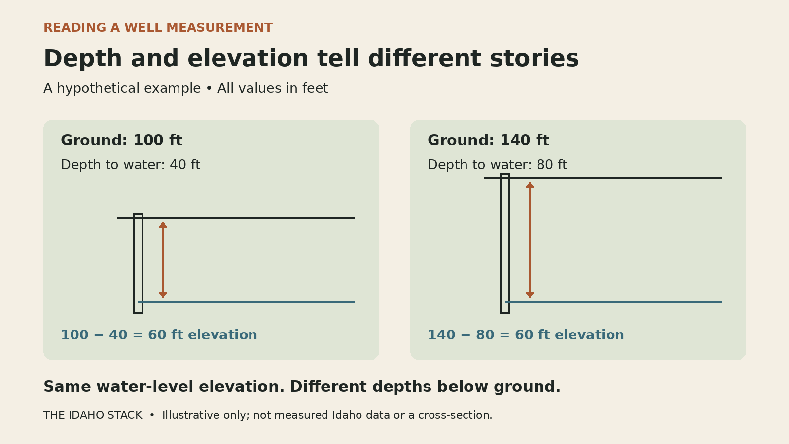
For a reader comparing records, that means checking the well identity, measurement date, units and reference before treating two numbers as a trend. The depth interval represented by a well matters too. A regional map becomes more useful when those differences remain visible rather than disappearing into one colored surface.
There is a similar caution about time. IDWR’s March mapping presentation describes using spring observations and, for some long comparisons, ranges of years with median values. A map labeled “2000 to 2025” may summarize observations around those periods; it is not necessarily a subtraction of readings on two exact dates.
The model has a public budget and named operators
The new readings will inform the Western Snake Plain Aquifer Model, which connects questions in the Treasure Valley with the Mountain Home area. In its August 2025 project briefing, IDWR listed a combined $1.15 million model-development budget: $850,000 from the Idaho Water Resource Board over fiscal years 2025–2028 and $300,000 from USGS.
That is a published project budget, not verified spending to date or a price for the 400-well survey alone. The briefing assigns model construction, calibration and report preparation to USGS. IDWR provides modeling support and facilitates technical input; the board funds the work through its Secondary Aquifer Fund. IDWR also maintains the public groundwater database.
The March 2026 work plan calls for public model files, processing scripts and documentation. It identifies potential questions about recharge near Mountain Home and pumping near Mayfield. Those are uses the research could support, not answers already established by this fall’s measurements.
Residents can start with IDWR’s groundwater-level resource page, which links to its map, hydrographs and bulk download. The next useful evidence will be the actual survey records, their coverage and the repeat observations. More wells can improve the map; understanding which wells were measured is how the public can judge that improvement.
Sources and limits
Public documents reviewed October 19, 2026. The September survey notice supplies the scheduled field dates and participation details. Technical committee presentations supply the data-gap rationale, selection process, budget, responsibilities and proposed model uses. Explanations of how to compare records are our analysis.
- IDWR survey notice, September 22, 2026 — planned additional wells, field window, 2027 repeats and public-data destination.
- Treasure Valley Synoptic Well Selection, June 3, 2026 — PDF pages 3, 9–10 and 13: coverage gaps, scope and scoring.
- WeSPAM introduction, August 26, 2025 — PDF pages 19–21: budget, agency roles and transparency.
- Project objectives, March 10, 2026 — PDF pages 2, 9 and 12–14: planned products and potential scenarios.
- Groundwater-level change maps, March 10, 2026 — PDF pages 4–6: comparison method.
- IDWR groundwater monitoring and data access · USGS SIR 2020–5134, section on estimating hydraulic heads: measurement-reference method, not an Idaho finding.
We did not verify the number of completed survey visits, inspect the new study’s individual readings, reconcile current project expenditures or establish a post-survey aquifer trend. The interactive portal returned no readable dataset in our retrieval; the state resource page is provided as a route to it. No claim about a particular well, development approval or water right follows from this article.
For a documented correction, send the claim and supporting source.